posted
The regular maps of the world base on the Mercator model are wrong. Those maps make Europe, Greenland and Russia big and Africa small. The real map of the world is the Peters projection map that show Africa big and Europe, Greenland, Russia and Alaska smaller.
posted
That's a funny trivia. I call those maps equal area maps. As they maintain the relative area size between any regions. Although they change the shape of most regions.
IIRC the Mercator model are useful for navigation because they maintain the correct angle between two points on a 2D map (iirc).
All this is related of course to the "difficulty" of projecting a 3D surface like earth on a 2-D surface like piece of paper or computer screen. Any terrestrial globe you may have at home maintain both the relative area size and angle between any points.
In 1973, Arno Peters, a German filmmaker and journalist, called a press conference to denounce the widely accepted map of the world known as the "Mercator Map" (above). Peters' position was that the Mercator Projectiona cylindrical projection first developed in 1569 by Flemish cartographer Gerardus Mercatorwas not only inaccurate, but downright racist. Peters pointed out that the Mercator map has a distortion in the northern hemisphere, making North American and Eurasian countries appear much larger than they actually are. For example, Greenland and Africa are shown as roughly the same size, although in reality Africa is about fourteen times larger. In contrast, the regions along the equatorAfrica, India, and South America, to name a fewappear smaller, especially when seen next to the distorted northern half of the map. It was Peters' belief that this error led many in the developed world to ignore the struggles of the larger, poorer nations near the equator.
Of course Peters had a suggestion on how to fix this problemhis own map. The Peters Projection map, which claimed to show the world in a more accurate, equal-area fashion.
The Gall-Peters Projection
Because Peters' map showed the size of developing nations more accurately, charitable organizations that worked in those regions quickly gave him their endorsement. Eventually his map became so well received that some were calling for an all-out ban on the Mercator map, believing it to be an outmoded symbol of colonialism.
The thing is, cartographers agreed that the Mercator map was outdated, inaccurate, and wasn't the best way to represent the world's landmasses. They'd been calling for the use of a new projection since the 1940s.
One of the reasons experts wanted to move away from the Mercator was because of the distortion. However, they also understood that it was distorted for good reason. The Mercator map was intended as a navigational tool for European mariners, who could draw a straight line from Point A to Point B and find their bearings with little trouble. Because it was made for European navigators, it was actually helpful to show Europe larger than it really was. It wasn't a political statement, but a decision made purely for ease-of-use.
However, the biggest insult to cartographers was the Peters projection itself. Peters claimed to have created the projection, when in fact, it was essentially the same thing as devised in 1855 by a cartographer named James Gall. Many have recognized this similarity and now you'll often see Peters' map called "The Gall-Peters Projection."
Today, the controversy is mostly dead. Both projections are seen as flawed and have fallen into disuse as more accurate maps have been developed. In classrooms now, you're more likely to see the Robinson Projection or the Winkel Tripel Projection. The Gall-Peters map is still favored by some organizations, though many map publishers don't even produce it anymore. And despite the controversy, the Mercator projection is still one of the most widely used navigational tools in the worldit's the primary projection for Google Maps.
_______________________________________________
The Robinson Projection
Robinson called this the orthophanic projection (which means "right appearing"), but this name never caught on. In at least one reference book, this projection is termed the Pseudocylindrical Projection with Pole Line, which is highly descriptive (the "pole line" comes from the fact that the North and South Poles on a Robinson projection are shown as lines and not points), but so unwieldily that it is not surprising that this name also failed to gain much acceptance.
The "Robinson projection" is unquestionably the name of choice. The Robinson projection is highly unique. Unlike all other projections, Professor Robinson did not develop this projection by developing new geometric formulas to convert latitude and longitude coordinates from the surface of the Model of the Earth to locations on the map. Instead, Robinson used a huge number of trial-and-error computer simulations to develop a table that allows a cartographer to look up how far above or below a Robinson map's equator a particular line of latitude will be located, and then to estimate (via a simple interpolation process) where along this line a particular longitude will fall. To this day, no other projection uses this approach to build a map.
Uses The Robinson projection is unique. Its primary purpose is to create visually appealing maps of the entire world. It is a compromise projection; it does not eliminate any type of distortion, but it keeps the levels of all types of distortion relatively low over most of the map. Source: -Denis J. Dean, Colorado State University
Robinson Projection This map shows the earth with a flat top and bottom. The lines of latitude are straight lines. The lines of longitude are curved lines. In a Robinson projection map, the areas look correct. But the distances and compass directions are not correct. Areas near the North and South Poles appear flattened.
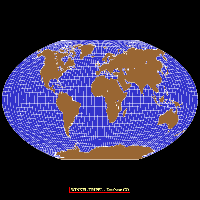
WINKEL TRIPEL Presented by Oswald Winkel (1873-1953) of Germany in 1921. Obtained by averaging coordinates of Equidistant Cylindrical and Aitoff (not Hammer-Aitoff) projections. Winkel applied the name Tripel, normally meaning triple.
Distortion Moderate except near outer meridians in polar regions
Winkel Tripel Projection This map uses curved lines to show latitude and longitude. Study the shapes of the North and South Pole regions. They are more accurate than they are in the Robinson Projection. Recently, the National Geographic Society began to use this kind of projection map. They use it for all of their maps of the world.Posts: 42940 | From: , | Registered: Jan 2010
| IP: Logged |
posted
Western countries can use their satellites to take pictures of the world land masses in order to make an accurate map of the world. I think they did that already, the reason they do not publish their finding is because the result support the Peters map that Africa and Latin America are very big and Europe, Russia, Greenland and Canada are smaller.
Mercator map
Peters map
I think the Peters map is more accurate because Africa, Latin America, India, China, Australia are bigger and Europe, Russia, Canada and Alaska are smaller.
Posts: 5374 | From: sepedat/sirius | Registered: Jul 2012
| IP: Logged |
the most accurate and up to date map of its kind. The world is depicted in a Van Der Grinten Map Projection with a 30 latitude/longitude grid. A multitude of various data sources are combined to produce this maps unique detail of the planet. Land imagery is based on data collected by NASA's MODIS satellite instrumentation in August 2004.
Posts: 42940 | From: , | Registered: Jan 2010
| IP: Logged |
posted
Lioness that so call Satellite map look like the Mercator map. Greenland is almost the same size as Africa. Alaska is bigger then Mexico when Mexico is realy bigger then Alaska. Eurocentrist scientists are good liar.
quote:Originally posted by mena7: Lioness that so call Satellite map look like the Mercator map. Greenland is almost the same size as Africa. Alaska is bigger then Mexico when Mexico is realy bigger then Alaska. Eurocentrist scientists are good liar.
So making Greenland too big is racist? Nobody cares about Greenland. It's popualtion is 57 thousand. The population of Greenland consists of Inuit, Europeans, persons of mixed Inuit and Danish blood, Danes and others.
The native Inuit population (including mixed persons) is approximately 85%-90%
The white color is ice. It's not the same size as Africa. On the Satellite map the fragmented left part of white are Isands part of Canadian territory called Nunavut, here in red:
.
Greenland is the world's largest island, over three-quarters of which is covered by ice sheet outside of Antarctica. With a population of 56,370 (2013), it is the least densely populated country in the world.
Greenland has been inhabited off and on for at least the last 4,500 years by Arctic peoples whose forebears migrated there from Canada.Norsemen settled on the uninhabited southern part of Greenland beginning in the 10th century. Inuit peoples arrived in the 13th century. The Norse colonies disappeared in the late 15th century. In the early 18th century, Scandinavia and Greenland came back into contact with each other, and Denmark established sovereignty over the island.
[IMG][/IMG]
^^^This might be more accurate I think it's a Winkel Tripel map based on the Satelliite
The Mercator is distorted for navigation purposes
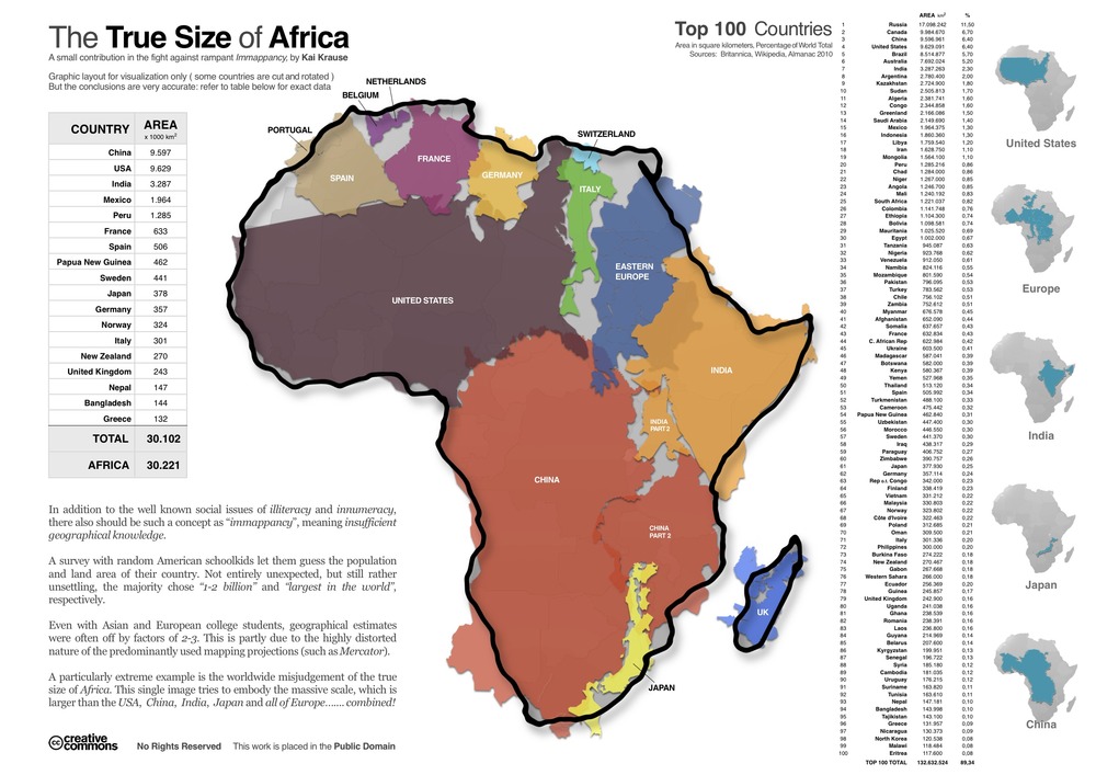
Africa is 3.3 times the size of the United States Not far from the same, number, Africa has 3.2 times the population of the U.S. China has more people than Africa though
Posts: 42940 | From: , | Registered: Jan 2010
| IP: Logged |


 UBBFriend: Email this page to someone!


 Printer-friendly view of this topic